 |
|
|
|
|
|
| |
|
|
 |
CORINE
means 'Coordination of Information on the
Environment' |
|
| |
and it was a prototype
project working on many different environmental issues, especially on
Land Cover
Classification.
In 1985 the CORINE
programme was initiated in the European Union in
order to harmonize methods of data collection and evaluation.
The most important
aims of CORINE formulated by the European Commission are:
- to compile information
on the state of environment eith regard to certain topics which have
priority to all Member States of the Community,
- to coordinate the
compilation of data and the organization of information within the Member
States or at international level,
- to ensure that
information on biophysical units
is consistent and that data are compatible as a result of
harmonized methods of data collection and evaluation.
- The concept of
terrestrial environment relates to the interaction between natural components
of the geosphere and biosphere as well as to their interaction with
social and economic factors, with special emphasis on the territory
in which they are deeply rooted
|
|
|
The
CORINE databases and several of its programmes |
|
| |
have been taken over
by the EEA with its Topic Centres  European
Topic Centre on (CORINE) Land Cover (ETC/LC, Sweden), and the European
Topic Centre on Terrestrial Environment) (ETC/TE - Spain). European
Topic Centre on (CORINE) Land Cover (ETC/LC, Sweden), and the European
Topic Centre on Terrestrial Environment) (ETC/TE - Spain).
|
|
| |
|
|
 |
One
of these programmes is an inventory
of land cover,
today called CORINE Land Cover (CLC). |
|
| |
It's
NOT a habitat classification. |
|
|
|
|
| |
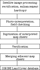 |
- Method: Computer
assisted satellite photo-interpretation
- Ancillary
data: topographic maps, vegetation maps, land use statistics,
etc
- Working scale:
1:100,000
- Minimum mapping
unit: 25 hectares
- Minimum linear
feature width: 100 m (Linear features smaller than 100
m wide are not considered and generalised)
- Nomenclature:
hierarchically structured in 3 levels: 44 classes for level 3
(cf. table below!)
- Cartographic
projection: Lambert azimuthal equal area
- Various projections
in country databases
- Implementation:
national teams
- Supervision:
Land Cover Technical Unit
- Overall classification
reliability: better than 85 percent
- Geometric
accuracy compared to topographic map: <100 meters RMS
|
| Flowchart
of CLC mapping |
Basic
characteristics of the CLC database |
|
|
| |
|
|
| |
 |
|
| |
WWW-Source:
URL http://europa.eu.int/comm/agriculture/publi/landscape/about.htm |
|
| |
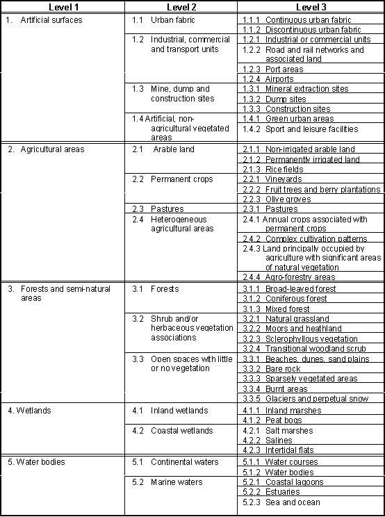
CORINE
44 Classes at level 3 - For details compare "Nomenclature
Definitions" (page 22) |
|
| |
|
|
|
Important:
The CLC Inventory is based on satellite images
as the primary information source. The use of earth observation data has
important implications on the nomenclature, mapping unit and scale.
|
|
| |
|
|
| |
- This database is
operationally available for most areas of Europe.
- Original inventories,
based on and interpreted from satellite imagery as well as ancillary
information sources, are stored within national institutions.
- The European reference
database is owned by GISCO, the European Commission geographical information
system, which is a part of the European Statistic Agency, Eurostat.
- The ETCs
are managing the CORINE database (the production database) on behalf
of EEA and delivers the updated database to GISCO every 12 months.
|
|
| |
|
|
 |
The results
of the large-scale CORINE Land Cover (CLC)
- biophysical -
Classification |
|
| |
are
not directly comparable with the results of the small-scale
EUNIS or NATURA 2000 classification results, respectively.
Anyhow, the classes
of CLC can be cross-matched to those of the EUNIS Habitat types (ecosystems)
classification.
|
|
| |
|
|
|
EXAMPLE
for
CORINE Land Cover Classification |
 |
| |
|
|
| |
|
|
|
|
|
|
|
 |
Basic
Information
on CORINE data collection, management and analysis |
 |
|
|
|
|
 |
 |
 |
Part 1. Methodology (with nomenclature, method, etc., 94 pp.) |
3,56MB |
| |
 |
|
Part
2.1 Nomenclature (illustrations)
|
3,84MB |
| |
|
|
Part
2.2 Agricultural Areas (illustrations, 16 pp.) |
3,74MB |
| |
|
|
Part
2.3 Forests and semi-natural areas (16 pp.) |
4,23MB |
| |
|
|
Part
2.4 Wetlands (illustrations, 8 pp.) |
1,42MB |
| |
|
|
Part
2.5 Waterbodies (illustration, 8 pp.) |
1,62MB |
| |
 |
|
|
|
| |
 |
|
Corine
land cover update 2000: Technical guidelines (56 pp.) |
1,12MB |
| |
|
|
|
|
|
|
|
|
|
|
| |
|
|
 |
 |
|
|
|
| |
Copyright
© Dr. Harald Kehl
Alumnus der TU-Berlin - Institut für Ökologie
Updated
on
2020-11-08
|
 |
|